


Southern Ontario bracing for plenty of rain and strong winds.
Significant rainfall is heading for southern Ontario.
An Alberta clipper and Texas low will combine over the Great Lakes and intensify in strength later in day Thursday, bringing along with it mild temperatures, plenty of rain and strong winds.
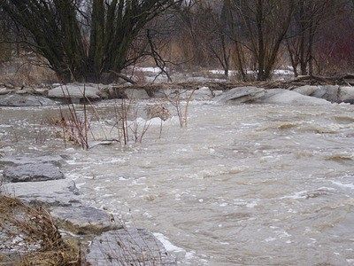
Environment Canada has issued a rainfall warning saying anywhere from 25-50 mm of rain is expected to fall on most of southern Ontario. The highest amounts are forecasted for the Windsor-Sarnia to Niagara-Hamilton corridor. There is the risk for thunderstorms Thursday afternoon and evening.
The Ottawa Valley are an exception to this forecast; they could see several hours of freezing rain with this system before transitioning over to rain.
The rain is expected to end by Friday morning in southwestern Ontario but behind that are strong winds, gusting from 70 to 80 km/h along with colder temperatures for the afternoon. Any precipitation for late-day Friday will most likely fall in the form of snow which could cause some dangerous driving conditions for the commute home.
People are being reminded to avoid the local waterways with slippery waterbanks, fast flowing water and unstable ice being a major concern with the snow and ice melt.
 Woodstock Home and Lifestyle Show Returns this Weekend
 Nominations Open for Tillsonburg Citizen of the Year
 PJHL Playoff Recap - March 17th
 UPDATE: Video Footage Wanted for Death Investigation
 MURC: Coming Soon to Ingersoll!
 Candidate Information Session Coming Up
 EZT Remembers Former Ward 3 Councillor
 SWPH Issues Cold Weather Alert
 UPDATE: Strong Winds Continue this Morning
 Woodstock Resident Charged with Speeding
 Interview with the Mayor - March 16th, 2026
 Woodstock Driver Charged in Brant County
 PJHL Playoff Recap - March 13th to March 15th
 March Break Safety Tips from Oxford OPP
 Oxford-Elgin Rainbow Research Project Underway
 OPP: Plan Ahead Before St. Paddy's Day Festivities
 Another Friday the 13th in Port Dover Today
 Hansen Parents Visit Artemis II Explorers Club at IDCI
 East Oxford Parents Respond to AARC Announcement
 Strong Winds Expected in Oxford


Comments
Add a comment