


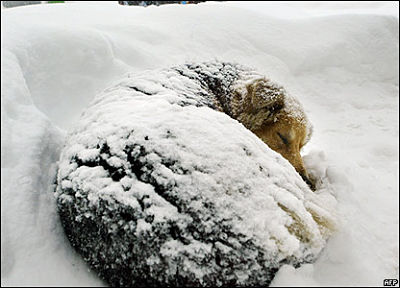
The coldest snap of the winter is behind us and it looks like it will be smooth sailing the rest of the way
The worst cold snap of the winter is over and it appears we won't have to endure any more temperatures of minus 20 in Oxford County.
A Cold Weather Alert was issued on Friday and with the wind chill the coldest it got this weekend was minus 33 in the County. However meteorologist with Environment Canada Geoff Coulson tells Heart FM that the worst is over and we should go back to our relatively mild winter.
"Chances are pretty good that that will be the coldest temperatures of the winter, the forecast for the rest of February is calling for seasonal values, maybe somewhat milder than seasonal, the preliminary look at the month of March at this time also indicating the temperatures overall should be seasonal or again milder than seasonal."
Coulson says we will get some cold weather on Wednesday night and the wake up temperature on Thursday morning will be around minus 14.
"It looks like the only day at this point where the temperatures will be colder than normal will be early Thursday morning, we are looking at wake up temperatures on Thursday morning at minus 14, normal lows for the area this time of year are about minus 9 but the temperatures bounce back right after that and the high for Thursday will be minus 3."
Coulson says the rest of the week is shaping up to have seasonal or below seasonal temperatures.
 Zorra Township Candidate Profile - Michael Kukhta
 Supplies4Students Returns to Oxford County
 Oxford County Power Outages
 Woodstock Candidate Profile - Bernia Martin
 Oxford OPP Briefs - June 30th
 Arpan Khanna Appointed to New Role
 Tip Tuesday with the Oxford OPP - June 2026
 Annual Highland Games Return to Embro
 Woodstock Police Service Briefs - June 30th
 Tillsonburg Candidate Profile - Kelly Spencer
 Heat Wave Brings Heat Warning
 GoFundMe Created Following Work Incident
 OPP Remind Public on Helmet Safety
 Tillsonburg Candidate Profile - Chris Rosehart
 Canada Day Celebrations Coming to Woodstock
 Zorra Township Candidate Profile - Katie Grigg
 Oxford OPP Continue to Investigate Pride Flag Incidents
 Wienerfest Hits Burford Fairgrounds this Weekend
 South-West Oxford Candidate Profile - George Klosler
 Nostalgia Days Fast Approaching in Norwich


Comments
Add a comment