


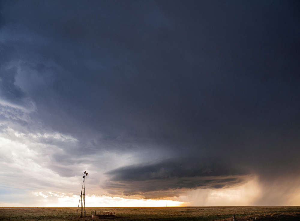
Tornado warnings were issued in London and Oxford County Tuesday evening.
UPDATE (May 22nd @ 6:00 a.m.) - The Northern Tornadoes Project has confirmed that a tornado touched down north of Belmont.
Officials say it was located in Derwent, which is located along on Westchester Bourne, just before Highway 401.
The Northern Tornadoes Project used videos and radar data for its preliminary investigation, and will visit the area to determine the intensity and track of the tornado.
It also says another storm created an EF1 downburst, which brought winds up to 145 kilometres per hour and caused even more damage east of London. An EF1 is when a strong column of air descends rapidly from a thunderstorm and generates destructive straight-line winds once it hits the ground.
---
OXFORD - It's the calm after the storm in southwestern Ontario.
We had quite the system move through the region yesterday evening. Environment Canada issued a tornado warning at around 5:20 p.m. in the London area and Warning Preparedness Meteorologist Monica Vaswani says that is where most of the damage occurred.
"There were reports of many downed trees and power outages. Even in places like St. Thomas we had a couple of reports of windows blown out in vehicles and there was also a semi truck on its side."
The storm system associated with the tornado warning headed east, and that's why a warning was issued in Oxford County at around 6:06 p.m.. This warning highlighted several locations where rotations were possible based on the radar, including Burgessville, but Vaswani says nothing was confirmed for those areas.
She adds the Northern Tornadoes Project investigates based on where the damage occurred.
"They are currently in the process of doing their damage surveys. Specifically, southeast of London there were reports of a tornado in the Belmont area, so I believe that general region is where they are canvassing to determine if a tornado did in fact occur."
Looking at the forecast, Vaswani says we should have a break from stormy conditions at least for a few days.
"We don't really have any threat of thunderstorms really for most of southern Ontario over the next couple of days. Saturday is the first day that looks like there is some potential because there is a new system coming in from the United States into southwestern Ontario, but it's too early to say if its going to be severe weather. Once we get into the work week next week, we start to get into temperatures in the 20s again, so I would say next week is when you need to keep an eye on the sky a little bit more again because those warmer temperatures will likely bring the threat of some showers or thunderstorms."
 Heat Wave Brings Heat Warning
 GoFundMe Created Following Work Incident
 OPP Remind Public on Helmet Safety
 Tillsonburg Candidate Profile - Chris Rosehart
 Canada Day Celebrations Coming to Woodstock
 Zorra Township Candidate Profile - Katie Grigg
 Oxford OPP Continue to Investigate Pride Flag Incidents
 Wienerfest Hits Burford Fairgrounds this Weekend
 South-West Oxford Candidate Profile - George Klosler
 Nostalgia Days Fast Approaching in Norwich
 Residential Fire in Tillsonburg
 SWOX Candidate Profile - Paul Buchner
 Interview with the Warden - June 25th, 2026
 Environment Canada Issues Yellow Watch for Thunderstorms
 Sally Creek Car Show Expands for DASO
 School's Out for Summer in Oxford County!
 SWPH Issues Drug Watch for Oxford and Elgin
 Norwich Township Candidate Profile - Karl Toews
 OPP Release Results from Stop, Look and Live Campaign
 Proxi 230 Car Cruise Begins Tomorrow


Comments
Add a comment